Riguardo questo articolo
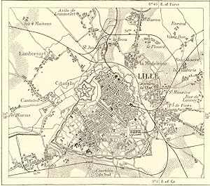
LILLE,Nord-Pas-de-Calais,Northern France,1800s Antique Map LILLE,Nord-Pas-de-Calais ,Northern France,1800s Antique Map HISTORICAL MAP CHART Lille is a city in northern France on the De?le River. It is the capital of the Nord-Pas-de-Calais r?gion. It is also the pr?fecture (capital) of the Nord d?partement. It lies near the border with Belgium and its Dutch name is Rijsel.In 1312, the city of Lille was ceded to France but was subsequently subjected to Burgundian, Austrian, and Spanish rule. It was part of the Spanish Netherlands, until it was conquered by Louis XIV and incorporated into France in 1668. The city's fortifications were upgraded by S?bastian Le Prestre de Vauban. In the 19th century Lille became the centre of French industry due to the large nearby coal deposits. It thus became a central part of the country's rail network. From the 12th century, the fame of the Lille cloth fair began to grow. In 1144 Saint Sauveur parish was formed, which would give its name to the modern-day quartier saint Sauveur. The counts of Flanders, Boulogne, and Hainaut came together with England and the Holy Roman Empire of Germany and declared war on France and King Philippe Auguste, a war that ended with the French victory at Bouvines in 1214. Count Ferrand of Portugal was imprisoned and the county fell into dispute: it would be his wife, Jeanne, Countess of Flanders and Constantinople, who ruled the city. They say she was well-loved by the residents of Lille, who by that time numbered 10,000. The 16th century was marked, above all, by the outbreak of the Plague, a boom in the regional textile industry, and the Protestant revolts. The first Calvinists appeared in the area in 1542; by 1555 there was anti-Protestant repression taking place. In 1578, the Hurlus, a group of Protestant rebels, stormed the castle of the Counts of Mouscron. They were removed four months later by a Catholic Wallon regiment, after which they tried several times between 1581 and 1582 to take the city of Lille, all in vain. The Hurlus were notably held back by the legendary Jeanne Maillotte. At the same time (1581), at the call of England's Queen Elisabeth I , the north of the Spanish Netherlands, having gained a Protestant majority, successfully revolted and formed the United Provinces. In the aftermath of the French Revolution, the Austrians, then in the United Provinces, laid seige to Lille. The "Column of the Goddess", erected in 1842 in the "Grand-Place", is a tribute to the city's resistance, led by Mayor Fran?ois Andr? The city continued to grow, and by 1800 held some 53,000 residents, leading to Lille becoming the county seat of the Nord d?partment in 1804. In 1846, a rail line connecting Paris and Lille was built. At the beginning of the 19th century, Napoleon I's continental blockade against the United Kingdom led to Lille's textile industry developing itself even more fully. The city was known for its cotton, and the nearby towns of Roubaix and Tourcoing worked wool. In 1853, Alexandre Desrousseaux composed his famous lullaby Dors mon p'tit quinquin. In 1858, an imperial decree led to the annexation of the adjacent towns of Fives, Wazemmes, and Moulins. Lille's population was 158,000 in 1872, growing to over 200,000 by 1891. In 1896 Lille became the first city in France to be led by a socialist, Gustave Delory. 1890s Wood Engraving, 1800s Antique Map Approximate Overall Size: 7 X 10 1/2 inches CONDITION: Book Plate INTEXT MAP - Excellent Condition. Beautiful with excellent detail. There is Text on Front and Back Side. Codice articolo 7630
Contatta il venditore
Segnala questo articolo


