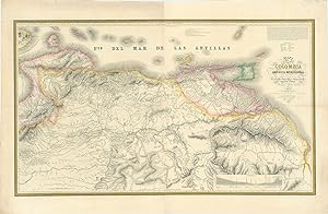
Riguardo questo articolo
Large engraved map printed on two conjoined sheets with wide margins (75 x 127 cm.; overall 91 x 140 cm.) outline hand-colour. Nicks and creases to outer edges of the margins professionally repaired, original vertical centre-fold crease and additional horizontal crease at centre, overall very good. A rare map drawn and engraved by J.M. Cardaso and attributed posthumously in the cartouche to Felipe Bauza (1764 - 1834) collector and cartographer extraordinaire, see Peter Barber's "Riches for the Geography of Spain Felipe Bauza and his topographical collections 1789-1849". Top right engraved in the map is a short account of the cartographic sources involved in its construction from Admirals Cosm Churucca and Joaquín Francisco Fidalgo, to the astronomer Jos Joaquin Ferrer, Baron Alexander von Humboldt and cartographer Joaquin Moreno Gran Colombia or Greater Colombia, officially the Republic of Colombia, was a state that encompassed much of northern South America and part of southern Central America from 1819 to 1831. It included present-day Colombia, mainland Ecuador (i.e. excluding the Galápagos Islands), Panama, and Venezuela, along with parts of northern Peru, northwestern Brazil, and Guyana. The terms Gran Colombia and Greater Colombia are used historiographically to distinguish it from the current Republic of Colombia, which is also the official name of the former state. Venezuela As noted in the official report of the Venezuela-British Guiana boundary arbitration The . . .map . . . of 1841 (is) by the Spanish engineer, Dem Felipe Bauza, comprising various provinces and parts of others, among these Guiana. It is founded upon the work of Churucca, and Fidalgo, as well as that Ferrer, and very particularly upon that of Baron de Humboldt, and on the unpublished charts and private plans of Solano, and on those of the campaign of General Murillo, and many documents of the officers of the Royal Armarda, Doz and Guerrero, and of the engineers Cramer and Primo de Rivera, of Don Jose de Inciarte and of the pilot of the Spanish trade to the Indies, Don Joaquin Morreno. It is duly certified in Madrid on May 4, 1898, by the archivist of the Archives of the Hydrographic Office, Senor Joaquin de Ariza, for James H. Reddan, Commissioner of the Government of Her Britannic Majesty. It shows all of the towns, villages, places, existing and ruined, missions, ranches, farms, sugar mills, cattle farms, castles, towers, Indian villages, silver mines, trails, roads and royal highways. It gives as the boundaries of British Guiana a line which starts from a point on Moruka Creek and runs in a southwesterly direction to the Rinocote Mountains, and from thence runs to the southeast and terminates at the source of the Pomeroon River, apparently in conformity with that of Humboldt, which is elsewhere analyzed. Codice articolo 61117
Contatta il venditore
Segnala questo articolo