Purtroppo questo libro non � pi� disponibile. Continuare acquisti.


Rare-Antique Map-SIEGE OF COPENHAGEN-Schleuen-Gross-1808
Schleuen
Data di pubblicazione: 1808
Usato
No binding
Da
Pictura Prints, Art & Books, Overasselt, Paesi Bassi
Valutazione del venditore 5 su 5 stelle
![]()
Venditore AbeBooks dal 1 novembre 2019
Riguardo questo articolo
Descrizione:
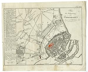
'TAF. XVII. PLAN DER BELAGERUNG VON COPENHAGEN (.).'Original antique military map showing a plan of the siege of Copenhagen in 1807.Made by Schleuen after Freiherr August Daniel von Gross.Engraving / etching on hand-laid (verge) paper.Sheet size: 24 x 19.8 cm (9.45 x 7.8 inch). Image size: 22.3 x 16.4 cm. (8.78 x 6.46 inch).SIEGE OF COPENHAGENPCO-A18-45BACKGROUND INFORMATIONFrom: 'Historisch-Militarischer Atlas zu des Freyherrn A.G. von Gross .'. , published in Amsterdam and Schleuen, Kunst- und Industrie-Comptoir in c.1808. This Atlas with 18 maps covers battles in various parts of Europe from 1792-1808 and served as a military handbook. Condition: fair, given age. A few spots / staining. Tear left in left paper edge, repaired. General age-related toning and/or occasional minor defects from handling. Please study scan carefully. Codice articolo PCO-20844
Dati bibliografici
Titolo: Rare-Antique Map-SIEGE OF ...
Data di pubblicazione: 1808
Legatura: No binding
Illustratore: Freiherr August Daniel von Gross